Imagine having the ability to see beyond what the human eye can see, revealing details hidden in everything from woods to battles.
That is, in essence, hyperspectral remote sensing (HRS). Think of it as turning ordinary satellite photos into an advanced investigative tool.
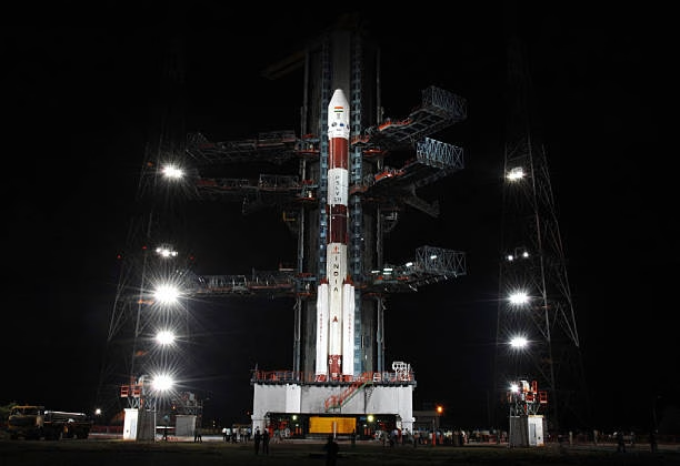
The Indian Space Research Organization (ISRO) is ready to launch the EOS-N1 Anvesha satellite into orbit with the PSLV-C62 mission. Anvesha is a hyperspectral satellite developed by the Defense Research and Development Organization (DRDO).
Explain hyperspectral
Spies and explorers occasionally used simple aerial photos to study landscapes. They would make educated guesses about what lay beneath using patterns, colors, and shapes. For example, they would recognize a river by its winding path or a forest by its green blobs.
The real game-changer is hyperspectral remote sensing. Instead of recording just a few colors, it records hundreds of incredibly thin slices of light that span the rainbow, from visible light to invisible infrared. Each small area in the image has a unique “fingerprint” based on how it reflects light.
It’s like having a scanner that can differentiate between different types of soil, plants, and even man-made objects based solely on their shine. This change means that we go from making educated guesses to making precise identifications because of intelligent software.
HOW DOES IT OPERATE?
HRS works because of the various ways that everything on Earth interacts with light. For example, water absorbs some light wavelengths while leaves reflect them back, creating a unique pattern akin to a barcode.
Scientists build libraries of these barcodes from pure samples (like just grass or dirt), which they then compare to what the satellite picks up.
To gather this information on the ground, experts use portable instruments called spectroradiometers, which measure light reflections up close.
When combined with Geographic Information Systems (GIS), HRS enables you to layer this data over actual locations. In addition to zooming in and spinning 3D models, you can pose queries like “Where’s the best spot to cross this river?”
WHY IS IT ESSENTIAL FOR DEFENCE?
In the modern era, HRS is a military secret weapon. It’s not about destruction, but about meticulous planning to keep people safe.
Here’s how it helps:
- Mapping the Ground: Have you ever questioned whether a tank can pass through mud without getting stuck? HRS differentiates between various soil types, such as sticky mud and sandy deserts, to forecast safe routes for troops or vehicles.
- Recognizing Hidden Dangers: It is not deceived by disguise. It can detect fake covers or unusual materials in urban areas, as well as differentiate between different plants that might hide technology. This makes it simpler to spot adversaries or locate hiding spots for allies in places like the diverse topography of India.
- Organizing Like an Expert: Construct virtual combat scenarios using 3D maps. Plan the routes or observe what can be seen from above. It’s like playing a video game with real stakes.
- Keep an eye out for any alterations caused by floods or earthquakes that might affect operations and issue early warnings.
A BRIEF FUTURE AND DIFFICULTIES AHEAD
There is no perfect technology. HRS can be expensive, and managing all that material is like organizing a huge library. Furthermore, the weather can sometimes make it difficult to see the image, and experts are needed for accurate interpretation.
But solutions are on the horizon: more training courses, less costly hybrid systems, and artificial intelligence to expedite the process.
Space missions will make this technology even more accessible, supporting climate monitoring, agriculture, disaster relief, and defense. Imagine farmers using it to detect diseased crops early or rescuers finding survivors in debris.
On January 12, India will launch the Anvesha satellite, which will bolster its aerial and strategic advantage as well as enable its prompt and efficient response to disasters and aid mitigation.